photo hurricane cuba

Hurricanes in Cuba

Travel information

Hurricanes are tropical cyclones. Danger arises through very high wind speeds, waves and heavy rainfalls. In Cuba a common word for a hurricane is 'ciclon'. Season is from May through November. Traditionally, through its well organized system of civil protection Cuba is better prepared for hurricanes then the USA or other countries of the Caribbean. Cuba suffers less loss of human life. Is is not safe from substantial material damages though.

Below, you can check the current weather status obtained from the US hurricane center.

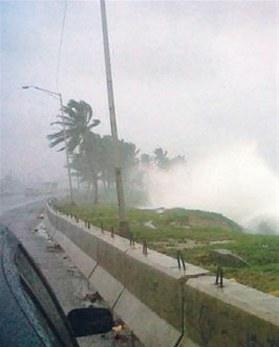
Hurricane season: June through October/November

Fri, 22 Sep 2023 15:40:22 GMT
Source: NHC Atlantic
More info and current maps


000 
ABNT20 KNHC 221153 
TWOAT  
 
Tropical Weather Outlook 
NWS National Hurricane Center Miami FL 
800 AM EDT Fri Sep 22 2023 
 
For the North Atlantic...Caribbean Sea and the Gulf of Mexico: 
 
Active Systems: 
The National Hurricane Center has issued its last advisory on  
Post-Tropical Cyclone Nigel, located over the northeast Atlantic. 
 
The National Hurricane Center is issuing advisories on Potential  
Tropical Cyclone Sixteen, located over the southwestern Atlantic. 
* Formation chance through 48 hours...high...80 percent. 
* Formation chance through 7 days...high...80 percent. 
 
Central Tropical Atlantic (AL90): 
Shower and thunderstorm activity associated with an area of low  
pressure located about 600 miles west-southwest of the Cabo Verde  
Islands continues to show signs of organization. Further development  
is expected, and a tropical depression is likely to form during the  
next couple of days while the system moves generally westward at 10  
to 15 mph. The system is then expected to turn west-northwestward  
early next week as it moves over the central tropical Atlantic. 
* Formation chance through 48 hours...high...70 percent. 
* Formation chance through 7 days...high...90 percent. 
 
&& 
 
Public Advisories on Potential Tropical Cyclone Sixteen are issued  
under WMO header WTNT31 KNHC and under AWIPS header MIATCPAT1. 
Forecast/Advisories on Potential Tropical Cyclone Sixteen are issued  
under WMO header WTNT21 KNHC and under AWIPS header MIATCMAT1. 
 
Additional information on Nigel can be found in High Seas Forecasts  
issued by the UK Met Office under WMO header FQNT21 EGRR and on the  
web at  
https://www.metoffice.gov.uk/weather/specialist-forecasts/coast-and- 
sea/high-seas-forecast. 
 
$$ 
Forecaster D. Zelinsky 

  ...STORM SURGE WARNINGS ISSUED FOR THE OUTER BANKS AND ADDITIONAL  PORTIONS OF THE TIDAL POTOMAC AND ALBEMARLE SOUND... ...TROPICAL STORM CONDITIONS SPREADING OVER PORTIONS OF COASTAL  NORTH CAROLINA...
 As of 11:00 AM EDT Fri Sep 22
 the center of Sixteen was located near 32.3, -75.6
 with movement N at 12 mph.
 The minimum central pressure was 996 mb
 with maximum sustained winds of about 50 mph.
 
Issued at 1100 AM EDT Fri Sep 22 2023  

000
WTNT31 KNHC 221451
TCPAT1
 
BULLETIN
Potential Tropical Cyclone Sixteen Advisory Number   5
NWS National Hurricane Center Miami FL       AL162023
1100 AM EDT Fri Sep 22 2023
 
...STORM SURGE WARNINGS ISSUED FOR THE OUTER BANKS AND ADDITIONAL 
PORTIONS OF THE TIDAL POTOMAC AND ALBEMARLE SOUND...
...TROPICAL STORM CONDITIONS SPREADING OVER PORTIONS OF COASTAL 
NORTH CAROLINA...
 
 
SUMMARY OF 1100 AM EDT...1500 UTC...INFORMATION
-----------------------------------------------
LOCATION...32.3N 75.6W
ABOUT 255 MI...405 KM E OF CHARLESTON SOUTH CAROLINA
ABOUT 200 MI...320 KM S OF CAPE HATTERAS NORTH CAROLINA
MAXIMUM SUSTAINED WINDS...50 MPH...85 KM/H
PRESENT MOVEMENT...N OR 350 DEGREES AT 12 MPH...19 KM/H
MINIMUM CENTRAL PRESSURE...996 MB...29.42 INCHES
 
 
WATCHES AND WARNINGS
--------------------
CHANGES WITH THIS ADVISORY:
 
The Storm Surge Watch has been upgraded to a Storm Surge Warning 
for Ocracoke Inlet to Duck, North Carolina, the Tidal Potomac south 
of Colonial Beach, and portions of the western Albemarle Sound.
 
SUMMARY OF WATCHES AND WARNINGS IN EFFECT:
 
A Storm Surge Warning is in effect for...
* Beaufort Inlet, North Carolina to Chincoteague, Virginia
* Chesapeake Bay south of Colonial Beach, Virginia
* Neuse and Pamlico Rivers
* Portions of Pamlico and Albemarle Sounds
 
A Tropical Storm Warning is in effect for...
* Cape Fear, North Carolina to Fenwick Island, Delaware
* Albemarle and Pamlico Sounds
* Tidal Potomac south of Cobb Island
* Chesapeake Bay south of North Beach
 
A Storm Surge Watch is in effect for...
* Surf City, North Carolina to Beaufort Inlet, North Carolina
* Remainder of Pamlico and Albemarle Sounds
 
A Storm Surge Warning means there is a danger of life-threatening
inundation, from rising water moving inland from the coastline,
during the next 36 hours in the indicated locations. For a depiction
of areas at risk, please see the National Weather Service Storm
Surge Watch/Warning Graphic, available at hurricanes.gov.  This is a
life-threatening situation.  Persons located within these areas
should take all necessary actions to protect life and property from
rising water and the potential for other dangerous conditions.
Promptly follow evacuation and other instructions from local
officials.
 
A Tropical Storm Warning means that tropical storm conditions are
expected somewhere within the warning area.
 
A Storm Surge Watch means there is a possibility of life-
threatening inundation, from rising water moving inland from the
coastline, in the indicated locations during the next 48 hours.
For a depiction of areas at risk, please see the National Weather
Service Storm Surge Watch/Warning Graphic, available at
hurricanes.gov.
 
For storm information specific to your area, including possible
inland watches and warnings, please monitor products issued by your
local National Weather Service forecast office.
 
 
DISCUSSION AND OUTLOOK
----------------------
At 1100 AM EDT (1500 UTC), the disturbance was centered near
latitude 32.3 North, longitude 75.6 West. The system is moving
toward the north near 12 mph (19 km/h). A north to north-northwest
motion is expected during the next couple of days. On the forecast
track, the center of the low will approach the coast of North
Carolina tonight, and then move across eastern North Carolina,
southeastern Virginia, and the Delmarva Peninsula Saturday and
Sunday.
 
Maximum sustained winds are near 50 mph (85 km/h) with higher gusts. 
Some strengthening is forecast before landfall, and the low is 
expected to become a tropical storm before it reaches the coast of 
North Carolina. Regardless of whether it becomes a tropical storm, 
the system is expected to bring tropical storm conditions to 
portions of the southeast and mid-Atlantic coasts.
* Formation chance through 48 hours...high...80 percent.
* Formation chance through 7 days...high...80 percent.
 
Tropical-storm-force winds extend outward up to 275 miles (445 km)
from the center. NOAA buoy 41025 at Diamond Shoals, North Carolina, 
recently reported a sustained wind of 40 mph (65 km/h) and a gust 
of 51 mph (83 km/h). 
 
The estimated minimum central pressure based on surface observations 
is 996 mb (29.42 inches).
 
 
HAZARDS AFFECTING LAND
----------------------
Key messages for this system can be found in the Tropical Cyclone
Discussion under AWIPS header MIATCDAT1, WMO header WTNT41 KNHC,
and on the web at hurricanes.gov/text/MIATCDAT1.shtml
 
STORM SURGE:  The combination of a dangerous storm surge and the
tide will cause normally dry areas near the coast to be flooded by
rising waters moving inland from the shoreline.  The water could
reach the following heights above ground somewhere in the indicated
areas if the peak surge occurs at the time of high tide...
 
Neuse and Bay Rivers...3-5 ft
Pamlico and Pungo Rivers...3-5 ft
Chesapeake Bay south of Colonial Beach...2-4 ft
Surf City, NC to Chincoteague, VA...2-4 ft
Albemarle Sound...2-4 ft
South Santee River, SC to Surf City, NC...1-3 ft
Chincoteague, VA to Manasquan Inlet, NJ...1-3 ft
Upper Chesapeake Bay...1-3 ft
Delaware Bay...1-3 ft
 
The deepest water will occur along the immediate coast in areas of
onshore winds, where the surge will be accompanied by dangerous
waves.  Surge-related flooding depends on the relative timing of the
surge and the tidal cycle, and can vary greatly over short
distances.  For information specific to your area, please see
products issued by your local National Weather Service forecast
office.
 
WIND:  Tropical storm conditions are reaching portions of the North 
Carolina coast within the warning area and will spread northward 
through Saturday.
 
RAINFALL:  The system is forecast to produce 3 to 5 inches of
rainfall, with localized amounts of 7 inches across portions of
eastern North Carolina and southeast Virginia from today into
Saturday. Across remaining portions of the Mid-Atlantic into
southern New England, 2 to 4 inches of rainfall are forecast from
later today into Sunday.  This rainfall may produce flash, urban,
and small stream flooding impacts.
 
SURF:  Swells generated by this system will affect much of the east
coast of the United States through this weekend.  These swells are
likely to cause life-threatening surf and rip current conditions.
Please consult products from your local weather office.
 
TORNADOES:  A few tornadoes are possible beginning tonight through
Saturday for portions of the mid-Atlantic Coast.
 
 
NEXT ADVISORY
-------------
Next intermediate advisory at 200 PM EDT.
Next complete advisory at 500 PM EDT.
 
$$
Forecaster Reinhart
 
Issued at 1500 UTC FRI SEP 22 2023  

424 
WTNT21 KNHC 221450
TCMAT1
 
POTENTIAL TROPICAL CYCLONE SIXTEEN FORECAST/ADVISORY NUMBER   5
NWS NATIONAL HURRICANE CENTER MIAMI FL       AL162023
1500 UTC FRI SEP 22 2023
 
NOTICE... LAND-BASED TROPICAL CYCLONE WATCHES AND WARNINGS ARE NO
LONGER INCLUDED IN THE TROPICAL CYCLONE FORECAST/ADVISORY...(TCM).
CURRENT LAND-BASED COASTAL WATCHES AND WARNINGS CAN BE FOUND IN THE
MOST RECENTLY ISSUED TROPICAL CYCLONE PUBLIC ADVISORY...(TCP).
 
POTENTIAL TROP CYCLONE CENTER LOCATED NEAR 32.3N  75.6W AT 22/1500Z
POSITION ACCURATE WITHIN  40 NM
 
PRESENT MOVEMENT TOWARD THE NORTH OR 350 DEGREES AT  10 KT
 
ESTIMATED MINIMUM CENTRAL PRESSURE  996 MB
MAX SUSTAINED WINDS  45 KT WITH GUSTS TO  55 KT.
34 KT.......240NE   0SE  60SW 210NW.
12 FT SEAS..240NE 120SE 160SW 180NW.
WINDS AND SEAS VARY GREATLY IN EACH QUADRANT.  RADII IN NAUTICAL
MILES ARE THE LARGEST RADII EXPECTED ANYWHERE IN THAT QUADRANT.
 
REPEAT...CENTER LOCATED NEAR 32.3N  75.6W AT 22/1500Z
AT 22/1200Z CENTER WAS LOCATED NEAR 31.6N  75.5W
 
FORECAST VALID 23/0000Z 33.2N  76.3W...TROPICAL CYCLONE
MAX WIND  55 KT...GUSTS  65 KT.
50 KT... 50NE  20SE  40SW  40NW.
34 KT...240NE  80SE  80SW 170NW.
 
FORECAST VALID 23/1200Z 34.9N  76.8W...INLAND
MAX WIND  50 KT...GUSTS  60 KT.
50 KT...  0NE  40SE   0SW   0NW.
34 KT...180NE 120SE  60SW  70NW.
 
FORECAST VALID 24/0000Z 36.8N  77.0W...INLAND
MAX WIND  40 KT...GUSTS  50 KT.
34 KT...150NE  90SE  40SW  40NW.
 
FORECAST VALID 24/1200Z 38.3N  77.0W...POST-TROP/EXTRATROP
MAX WIND  30 KT...GUSTS  40 KT.
 
FORECAST VALID 25/0000Z 39.3N  76.5W...POST-TROP/EXTRATROP
MAX WIND  25 KT...GUSTS  35 KT.
 
FORECAST VALID 25/1200Z...DISSIPATED
 
REQUEST FOR 3 HOURLY SHIP REPORTS WITHIN 300 MILES OF 32.3N  75.6W
 
INTERMEDIATE PUBLIC ADVISORY...WTNT31 KNHC/MIATCPAT1...AT 22/1800Z
 
NEXT ADVISORY AT 22/2100Z
 
$$
FORECASTER REINHART


Issued at 1100 AM EDT Fri Sep 22 2023  

000
WTNT41 KNHC 221453
TCDAT1
 
Potential Tropical Cyclone Sixteen Discussion Number   5
NWS National Hurricane Center Miami FL       AL162023
1100 AM EDT Fri Sep 22 2023
 
Surface observations indicate the low pressure system off the 
southeast U.S. coast is deepening this morning. Recent pressure and 
wind data from NOAA buoy 41002 suggest the pressure has fallen to 
around 996 mb. While surface analyses indicate there is still a 
front in close proximity to the low, deep convection has become more 
concentrated to the north of the center. In fact, GOES-16 1-min 
visible imagery suggests the low-level center is re-forming closer 
to the convection. The broad wind field is asymmetric, with the 
strongest observed winds occurring to the north and west of the 
frontal feature. A NOAA Saildrone sampling the system reported a 
sustained wind of 40 kt and a gust around 50 kt earlier this 
morning. Based on the available observations, the initial intensity 
is held at 45 kt. An Air Force Reserve Hurricane Hunter aircraft is 
scheduled to investigate the system this afternoon.

The initial motion of the cyclone is just west of due north (350/10 
kt). The system is forecast to move north-northwestward to northward 
through Saturday along the west side of a subtropical ridge over the 
western and central Atlantic. This motion will take the center of 
the cyclone inland over eastern North Carolina on Saturday morning 
and over the Mid-Atlantic region Saturday night and Sunday. The 
track guidance is in good agreement for this forecast. Based on the 
slight northward adjustment to the initial position, the updated NHC 
forecast is slightly faster than the previous one, showing the 
cyclone center just inland in 24 h.

Based on recent satellite and observational trends, the cyclone 
appears likely to strengthen during the next 12 h over the warm Gulf 
Stream waters. The more organized convective structure should also 
facilitate its transition to a tropical storm during the next 6-12 h 
as it starts to become separated from its frontal features and 
develops a smaller inner core. The near-term intensity forecast has 
been bumped up slightly (55 kt) before the system moves inland early 
Saturday. After landfall, the system is expected to weaken due to 
the negative influences of land interaction, drier air, and strong 
upper-level winds. This forecast shows extratropical transition by 
48 h with dissipation by 72 h, in good agreement with the GFS and 
ECMWF models. 

 
Key Messages:
 
1. Tropical storm conditions are expected along portions of the 
southeastern and mid-Atlantic U.S. coasts within the Tropical Storm 
Warning area today into Saturday night.
 
2. There is a danger of life-threatening storm surge inundation
over portions of eastern North Carolina and southeastern Virginia,
including Pamlico and Albemarle Sounds, the Neuse and Pamlico 
Rivers, the lower James River, and the lower Chesapeake Bay, where 
Storm Surge Warnings are in place.  Residents in these areas should 
follow advice given by local officials.
 
3. Heavy rainfall from this system could produce flash, urban, and 
small stream flooding impacts across portions of the Mid-Atlantic 
states from North Carolina to New Jersey through Sunday.
 
4. Swells generated by this system will affect much of the U.S.
east coast through the weekend, likely causing life-threatening
surf and rip currents.
 
 
FORECAST POSITIONS AND MAX WINDS
 
INIT  22/1500Z 32.3N  75.6W   45 KT  50 MPH...POTENTIAL TROP CYCLONE
 12H  23/0000Z 33.2N  76.3W   55 KT  65 MPH...TROPICAL CYCLONE
 24H  23/1200Z 34.9N  76.8W   50 KT  60 MPH...INLAND
 36H  24/0000Z 36.8N  77.0W   40 KT  45 MPH...INLAND
 48H  24/1200Z 38.3N  77.0W   30 KT  35 MPH...POST-TROP/EXTRATROP
 60H  25/0000Z 39.3N  76.5W   25 KT  30 MPH...POST-TROP/EXTRATROP
 72H  25/1200Z...DISSIPATED
 
$$
Forecaster Reinhart
 
Issued at 1500 UTC FRI SEP 22 2023                                              

000
FONT11 KNHC 221452
PWSAT1
                                                                    
POTENTIAL TROPICAL CYCLONE SIXTEEN                                  
WIND SPEED PROBABILITIES NUMBER   5                                 
NWS NATIONAL HURRICANE CENTER MIAMI FL       AL162023               
1500 UTC FRI SEP 22 2023                                            
                                                                    
AT 1500Z THE CENTER OF POTENTIAL TROPICAL CYCLONE SIXTEEN WAS       
LOCATED NEAR LATITUDE 32.3 NORTH...LONGITUDE 75.6 WEST WITH MAXIMUM 
SUSTAINED WINDS NEAR 45 KTS...50 MPH...85 KM/H.                     
                                                                    
Z INDICATES COORDINATED UNIVERSAL TIME (GREENWICH)                  
   ATLANTIC STANDARD TIME (AST)...SUBTRACT 4 HOURS FROM Z TIME      
   EASTERN  DAYLIGHT TIME (EDT)...SUBTRACT 4 HOURS FROM Z TIME      
   CENTRAL  DAYLIGHT TIME (CDT)...SUBTRACT 5 HOURS FROM Z TIME      
                                                                    
WIND SPEED PROBABILITY TABLE FOR SPECIFIC LOCATIONS                 
                                                                    
CHANCES OF SUSTAINED (1-MINUTE AVERAGE) WIND SPEEDS OF AT LEAST     
   ...34 KT (39 MPH... 63 KM/H)...                                  
   ...50 KT (58 MPH... 93 KM/H)...                                  
   ...64 KT (74 MPH...119 KM/H)...                                  
FOR LOCATIONS AND TIME PERIODS DURING THE NEXT 5 DAYS               
                                                                    
PROBABILITIES FOR LOCATIONS ARE GIVEN AS OP(CP) WHERE               
    OP  IS THE PROBABILITY OF THE EVENT BEGINNING DURING            
        AN INDIVIDUAL TIME PERIOD (ONSET PROBABILITY)               
   (CP) IS THE PROBABILITY OF THE EVENT OCCURRING BETWEEN           
        12Z FRI AND THE FORECAST HOUR (CUMULATIVE PROBABILITY)      
                                                                    
PROBABILITIES ARE GIVEN IN PERCENT                                  
X INDICATES PROBABILITIES LESS THAN 1 PERCENT                       
PROBABILITIES FOR 34 KT AND 50 KT ARE SHOWN AT A GIVEN LOCATION WHEN
THE 5-DAY CUMULATIVE PROBABILITY IS AT LEAST 3 PERCENT.             
PROBABILITIES FOR 34...50...64 KT SHOWN WHEN THE 5-DAY              
64-KT CUMULATIVE PROBABILITY IS AT LEAST 1 PERCENT.                 
                                                                    
                                                                    
  - - - - WIND SPEED PROBABILITIES FOR SELECTED LOCATIONS - - - -   
                                                                    
               FROM    FROM    FROM    FROM    FROM    FROM    FROM 
  TIME       12Z FRI 00Z SAT 12Z SAT 00Z SUN 12Z SUN 12Z MON 12Z TUE
PERIODS         TO      TO      TO      TO      TO      TO      TO  
             00Z SAT 12Z SAT 00Z SUN 12Z SUN 12Z MON 12Z TUE 12Z WED
                                                                    
FORECAST HOUR    (12)   (24)    (36)    (48)    (72)    (96)   (120)
- - - - - - - - - - - - - - - - - - - - - - - - - - - - - - - - - - 
LOCATION       KT                                                   
                                                                    
MONTAUK POINT  34  X   X( X)   X( X)   1( 1)   2( 3)   X( 3)   X( 3)
 
ISLIP NY       34  X   X( X)   X( X)   1( 1)   2( 3)   X( 3)   X( 3)
 
NYC JFK AIRPRT 34  X   X( X)   3( 3)   2( 5)   3( 8)   X( 8)   X( 8)
 
NYC CNTRL PARK 34  X   X( X)   X( X)   1( 1)   2( 3)   X( 3)   X( 3)
 
NEWARK NJ      34  X   X( X)   X( X)   1( 1)   2( 3)   X( 3)   X( 3)
 
TRENTON NJ     34  X   X( X)   1( 1)   2( 3)   2( 5)   X( 5)   X( 5)
 
NWS EARLE NJ   34  X   X( X)   X( X)   2( 2)   2( 4)   X( 4)   X( 4)
 
ALLENTOWN PA   34  X   X( X)   1( 1)   1( 2)   3( 5)   X( 5)   X( 5)
 
PHILADELPHIA   34  X   X( X)   2( 2)   3( 5)   3( 8)   X( 8)   X( 8)
 
ATLANTIC CITY  34  X   X( X)   3( 3)   3( 6)   2( 8)   X( 8)   X( 8)
 
BALTIMORE MD   34  X   1( 1)   6( 7)   8(15)   3(18)   X(18)   X(18)
 
DOVER DE       34  X   2( 2)   5( 7)   6(13)   2(15)   X(15)   X(15)
 
ANNAPOLIS MD   34  X   2( 2)   9(11)  10(21)   2(23)   X(23)   X(23)
 
WASHINGTON DC  34  X   2( 2)  11(13)  11(24)   2(26)   X(26)   X(26)
 
CAPE HENLOPEN  34  X  13(13)   9(22)   5(27)   2(29)   X(29)   X(29)
CAPE HENLOPEN  50  X   X( X)   X( X)   2( 2)   1( 3)   X( 3)   X( 3)
 
OCEAN CITY MD  34  3  18(21)  10(31)   4(35)   1(36)   X(36)   X(36)
OCEAN CITY MD  50  X   X( X)   1( 1)   3( 4)   1( 5)   X( 5)   X( 5)
 
PAX RIVER NAS  34  1   7( 8)  21(29)   8(37)   1(38)   X(38)   X(38)
 
WALLOPS CDA    34 10  19(29)  14(43)   2(45)   1(46)   X(46)   X(46)
WALLOPS CDA    50  X   X( X)   3( 3)   2( 5)   1( 6)   X( 6)   X( 6)
WALLOPS CDA    64  X   X( X)   X( X)   1( 1)   X( 1)   X( 1)   X( 1)
 
CHARLOTTESVIL  34  X   6( 6)  11(17)   5(22)   X(22)   X(22)   X(22)
 
RICHMOND VA    34  3  23(26)  31(57)   4(61)   1(62)   X(62)   X(62)
RICHMOND VA    50  X   X( X)   3( 3)   X( 3)   X( 3)   X( 3)   X( 3)
 
DANVILLE VA    34  3  13(16)   4(20)   X(20)   X(20)   X(20)   X(20)
 
NORFOLK NAS    34 12  39(51)  17(68)   1(69)   X(69)   X(69)   X(69)
NORFOLK NAS    50  X   1( 1)   4( 5)   X( 5)   1( 6)   X( 6)   X( 6)
 
NORFOLK VA     34 13  42(55)  14(69)   X(69)   X(69)   X(69)   X(69)
NORFOLK VA     50  X   X( X)   5( 5)   X( 5)   1( 6)   X( 6)   X( 6)
 
OCEANA NAS VA  34 34  30(64)  10(74)   1(75)   X(75)   X(75)   X(75)
OCEANA NAS VA  50  X   2( 2)  10(12)   X(12)   1(13)   X(13)   X(13)
OCEANA NAS VA  64  X   X( X)   1( 1)   X( 1)   X( 1)   X( 1)   X( 1)
 
ELIZABETH CTY  34 47  34(81)   5(86)   X(86)   X(86)   X(86)   X(86)
ELIZABETH CTY  50  X   4( 4)   5( 9)   X( 9)   X( 9)   X( 9)   X( 9)
 
GREENSBORO NC  34  3   6( 9)   1(10)   X(10)   1(11)   X(11)   X(11)
 
RALEIGH NC     34 22  31(53)   2(55)   X(55)   X(55)   X(55)   X(55)
 
ROCKY MT NC    34 49  35(84)   4(88)   X(88)   X(88)   X(88)   X(88)
ROCKY MT NC    50  X   3( 3)   2( 5)   X( 5)   X( 5)   X( 5)   X( 5)
 
CAPE HATTERAS  34 82  11(93)   1(94)   X(94)   X(94)   X(94)   X(94)
CAPE HATTERAS  50  1  19(20)   2(22)   X(22)   X(22)   X(22)   X(22)
CAPE HATTERAS  64  X   2( 2)   X( 2)   X( 2)   X( 2)   X( 2)   X( 2)
 
FAYETTEVILLE   34 55  12(67)   X(67)   X(67)   X(67)   X(67)   X(67)
 
CHARLOTTE NC   34  1   1( 2)   1( 3)   X( 3)   X( 3)   X( 3)   X( 3)
 
CHERRY PT NC   34 97   3(99)   X(99)   X(99)   X(99)   X(99)   X(99)
CHERRY PT NC   50  1  24(25)   1(26)   X(26)   X(26)   X(26)   X(26)
CHERRY PT NC   64  X   1( 1)   X( 1)   X( 1)   X( 1)   X( 1)   X( 1)
 
NEW RIVER NC   34 95   4(99)   1(99)   X(99)   X(99)   X(99)   X(99)
NEW RIVER NC   50  7  44(51)   1(52)   X(52)   X(52)   X(52)   X(52)
NEW RIVER NC   64  X   7( 7)   X( 7)   X( 7)   X( 7)   X( 7)   X( 7)
 
MOREHEAD CITY  34 95   4(99)   1(99)   X(99)   X(99)   X(99)   X(99)
MOREHEAD CITY  50  6  45(51)   X(51)   X(51)   X(51)   X(51)   X(51)
MOREHEAD CITY  64  X   6( 6)   1( 7)   X( 7)   X( 7)   X( 7)   X( 7)
 
SURF CITY NC   34 94   4(98)   X(98)   X(98)   X(98)   X(98)   X(98)
SURF CITY NC   50  4  24(28)   X(28)   X(28)   X(28)   X(28)   X(28)
SURF CITY NC   64  X   2( 2)   X( 2)   X( 2)   X( 2)   X( 2)   X( 2)
 
WILMINGTON NC  34 96   2(98)   X(98)   X(98)   X(98)   X(98)   X(98)
WILMINGTON NC  50  1   5( 6)   X( 6)   X( 6)   X( 6)   X( 6)   X( 6)
 
BALD HEAD ISL  34 92   2(94)   X(94)   X(94)   X(94)   X(94)   X(94)
BALD HEAD ISL  50  3   6( 9)   X( 9)   X( 9)   X( 9)   X( 9)   X( 9)
 
FLORENCE SC    34 15   4(19)   X(19)   X(19)   X(19)   X(19)   X(19)
 
LITTLE RIVER   34 70   3(73)   X(73)   X(73)   X(73)   X(73)   X(73)
 
MYRTLE BEACH   34 58   4(62)   X(62)   X(62)   X(62)   X(62)   X(62)
 
GEORGETOWN SC  34 28   1(29)   X(29)   X(29)   X(29)   X(29)   X(29)
 
CHARLESTON SC  34 16   3(19)   1(20)   X(20)   X(20)   X(20)   X(20)
 
BEAUFORT MCAS  34  6   2( 8)   1( 9)   X( 9)   X( 9)   X( 9)   X( 9)
 
$$                                                                  
FORECASTER REINHART                                                 


Potential Tropical Cyclone Sixteen 5-Day Uncertainty Track Image 
5-Day Uncertainty Track last updated Fri, 22 Sep 2023 14:54:27 GMT
  
Potential Tropical Cyclone Sixteen 34-Knot Wind Speed Probabilities  
Wind Speed Probabilities last updated Fri, 22 Sep 2023 15:22:40 GMT


Potential Tropical Cyclone Sixteen Link to Potential Storm Surge Flooding Map 
Potential Storm Surge Flooding Map last updated Fri, 22 Sep 2023 15:26:47 GMT


Potential Tropical Cyclone Sixteen Link to Storm Surge Watch/Warning Map 
Storm Surge Watch/Warning Map last updated Fri, 22 Sep 2023 14:55:02 GMT

Issued at  1120 AM EDT Fri Sep 22 2023
Issued at  1126 AM EDT Fri Sep 22 2023
Issued at  1127 AM EDT Fri Sep 22 2023
Issued at  1129 AM EDT Fri Sep 22 2023
Issued at  1132 AM EDT Fri Sep 22 2023
  ...NIGEL BECOMES EXTRATROPICAL... ...THIS IS THE LAST ADVISORY ON THIS SYSTEM...
 As of 9:00 AM GMT Fri Sep 22
 the center of Nigel was located near 46.3, -32.6
 with movement NE at 37 mph.
 The minimum central pressure was 976 mb
 with maximum sustained winds of about 70 mph.
 
Issued at 900 AM GMT Fri Sep 22 2023  

000
WTNT35 KNHC 220834
TCPAT5
 
BULLETIN
Post-Tropical Cyclone Nigel Advisory Number  28
NWS National Hurricane Center Miami FL       AL152023
900 AM GMT Fri Sep 22 2023
 
...NIGEL BECOMES EXTRATROPICAL...
...THIS IS THE LAST ADVISORY ON THIS SYSTEM...
 
 
SUMMARY OF 900 AM GMT...0900 UTC...INFORMATION
----------------------------------------------
LOCATION...46.3N 32.6W
ABOUT 640 MI...1030 KM NNW OF THE AZORES
MAXIMUM SUSTAINED WINDS...70 MPH...110 KM/H
PRESENT MOVEMENT...NE OR 55 DEGREES AT 37 MPH...59 KM/H
MINIMUM CENTRAL PRESSURE...976 MB...28.82 INCHES
 
 
WATCHES AND WARNINGS
--------------------
There are no coastal watches or warnings in effect.
 
 
DISCUSSION AND OUTLOOK
----------------------
At 900 AM GMT (0900 UTC), the center of Post-Tropical Cyclone Nigel 
was located near latitude 46.3 North, longitude 32.6 West. The 
post-tropical cyclone is moving toward the northeast near 37 mph (59 
km/h), and this general motion is expected to continue for the next 
day or so.  A slower northward or north-northwestward motion is 
expected this weekend.
 
Maximum sustained winds are near 70 mph (110 km/h) with higher
gusts. Gradual weakening is forecast during the next couple of
days
 
Tropical-storm-force winds extend outward up to 230 miles (370 km)
from the center.
 
The estimated minimum central pressure is 976 mb (28.82 inches).
 
 
HAZARDS AFFECTING LAND
----------------------
None.
 
 
NEXT ADVISORY
-------------
This is the last public advisory issued by the National Hurricane
Center on this system.
 
$$
Forecaster Kelly
 
Issued at 0900 UTC FRI SEP 22 2023  

147 
WTNT25 KNHC 220833
TCMAT5
 
POST-TROPICAL CYCLONE NIGEL FORECAST/ADVISORY NUMBER  28
NWS NATIONAL HURRICANE CENTER MIAMI FL       AL152023
0900 UTC FRI SEP 22 2023
 
NOTICE... LAND-BASED TROPICAL CYCLONE WATCHES AND WARNINGS ARE NO
LONGER INCLUDED IN THE TROPICAL CYCLONE FORECAST/ADVISORY...(TCM).
CURRENT LAND-BASED COASTAL WATCHES AND WARNINGS CAN BE FOUND IN THE
MOST RECENTLY ISSUED TROPICAL CYCLONE PUBLIC ADVISORY...(TCP).
 
POST-TROPICAL CYCLONE CENTER LOCATED NEAR 46.3N  32.6W AT 22/0900Z
POSITION ACCURATE WITHIN  25 NM
 
PRESENT MOVEMENT TOWARD THE NORTHEAST OR  55 DEGREES AT  32 KT
 
ESTIMATED MINIMUM CENTRAL PRESSURE  976 MB
MAX SUSTAINED WINDS  60 KT WITH GUSTS TO  75 KT.
50 KT....... 90NE 110SE  80SW  60NW.
34 KT.......180NE 200SE 190SW 110NW.
12 FT SEAS..200NE 300SE 480SW 480NW.
WINDS AND SEAS VARY GREATLY IN EACH QUADRANT.  RADII IN NAUTICAL
MILES ARE THE LARGEST RADII EXPECTED ANYWHERE IN THAT QUADRANT.
 
REPEAT...CENTER LOCATED NEAR 46.3N  32.6W AT 22/0900Z
AT 22/0600Z CENTER WAS LOCATED NEAR 45.4N  34.3W
 
FORECAST VALID 22/1800Z 48.8N  27.2W...POST-TROP/EXTRATROP
MAX WIND  50 KT...GUSTS  60 KT.
50 KT... 80NE 100SE  70SW  50NW.
34 KT...180NE 240SE 200SW 110NW.
 
FORECAST VALID 23/0600Z 53.0N  23.0W...POST-TROP/EXTRATROP
MAX WIND  50 KT...GUSTS  60 KT.
50 KT... 80NE  90SE  70SW  50NW.
34 KT...210NE 260SE 200SW 110NW.
 
FORECAST VALID 23/1800Z 56.4N  23.3W...POST-TROP/EXTRATROP
MAX WIND  50 KT...GUSTS  60 KT.
50 KT... 70NE  70SE  50SW  50NW.
34 KT...270NE 300SE 200SW 160NW.
 
FORECAST VALID 24/0600Z...DISSIPATED
 
REQUEST FOR 3 HOURLY SHIP REPORTS WITHIN 300 MILES OF 46.3N  32.6W
 
THIS IS THE LAST FORECAST/ADVISORY ISSUED BY THE NATIONAL HURRICANE 
CENTER ON THIS SYSTEM
 
$$
FORECASTER KELLY


Issued at 900 AM GMT Fri Sep 22 2023  

000
WTNT45 KNHC 220834
TCDAT5
 
Post-Tropical Cyclone Nigel Discussion Number  28
NWS National Hurricane Center Miami FL       AL152023
900 AM GMT Fri Sep 22 2023
 
Nigel has completed its transition to an extra-tropical cyclone this 
morning. Convection from earlier has waned, and is well displaced 
from the exposed low-level center. Based on a blend of an earlier 
partial ASCAT pass and subjective Dvorak satellite intensity 
estimates, the initial intensity is lowered to 60 kt for this 
advisory.
 
The system is encountering very strong vertical wind shear and ocean 
temperatures below 20 degrees Celsius. The system is forecast to 
continue to gradually weaken over the next couple of days. However, 
the system will remain a strong extra-tropical cyclone with an 
expanding wind field. The NHC intensity forecast is similar to the 
previous advisory and lies near the model consensus.
 
Nigel continues to race northeastward at 32 kt. A northeastward 
motion is forecast to continue the next day or so, as it remains in 
the flow along the southern edge of a deep mid-latitude trough. 
Afterwards, Nigel should rotate around the eastern side of a large 
extratropical cyclone over the North Atlantic, with the two 
extratropical systems merging in about 48 h.  The model guidance 
remains in fairly good agreement, and the NHC forecast lies in the 
center of the guidance envelope.
 
 
FORECAST POSITIONS AND MAX WINDS
 
INIT  22/0900Z 46.3N  32.6W   60 KT  70 MPH...POST-TROPICAL
 12H  22/1800Z 48.8N  27.2W   50 KT  60 MPH...POST-TROP/EXTRATROP
 24H  23/0600Z 53.0N  23.0W   50 KT  60 MPH...POST-TROP/EXTRATROP
 36H  23/1800Z 56.4N  23.3W   50 KT  60 MPH...POST-TROP/EXTRATROP
 48H  24/0600Z...DISSIPATED
 
$$
Forecaster Kelly
 
Issued at 0900 UTC FRI SEP 22 2023                                              

000
FONT15 KNHC 220834
PWSAT5
                                                                    
POST-TROPICAL CYCLONE NIGEL WIND SPEED PROBABILITIES NUMBER  28     
NWS NATIONAL HURRICANE CENTER MIAMI FL       AL152023               
0900 UTC FRI SEP 22 2023                                            
                                                                    
AT 0900Z THE CENTER OF POST-TROPICAL CYCLONE NIGEL WAS LOCATED NEAR 
LATITUDE 46.3 NORTH...LONGITUDE 32.6 WEST WITH MAXIMUM SUSTAINED    
WINDS NEAR 60 KTS...70 MPH...110 KM/H.                              
                                                                    
Z INDICATES COORDINATED UNIVERSAL TIME (GREENWICH)                  
   ATLANTIC STANDARD TIME (AST)...SUBTRACT 4 HOURS FROM Z TIME      
   EASTERN  DAYLIGHT TIME (EDT)...SUBTRACT 4 HOURS FROM Z TIME      
   CENTRAL  DAYLIGHT TIME (CDT)...SUBTRACT 5 HOURS FROM Z TIME      
                                                                    
WIND SPEED PROBABILITY TABLE FOR SPECIFIC LOCATIONS                 
                                                                    
CHANCES OF SUSTAINED (1-MINUTE AVERAGE) WIND SPEEDS OF AT LEAST     
   ...34 KT (39 MPH... 63 KM/H)...                                  
   ...50 KT (58 MPH... 93 KM/H)...                                  
   ...64 KT (74 MPH...119 KM/H)...                                  
FOR LOCATIONS AND TIME PERIODS DURING THE NEXT 5 DAYS               
                                                                    
PROBABILITIES FOR LOCATIONS ARE GIVEN AS OP(CP) WHERE               
    OP  IS THE PROBABILITY OF THE EVENT BEGINNING DURING            
        AN INDIVIDUAL TIME PERIOD (ONSET PROBABILITY)               
   (CP) IS THE PROBABILITY OF THE EVENT OCCURRING BETWEEN           
        06Z FRI AND THE FORECAST HOUR (CUMULATIVE PROBABILITY)      
                                                                    
PROBABILITIES ARE GIVEN IN PERCENT                                  
X INDICATES PROBABILITIES LESS THAN 1 PERCENT                       
PROBABILITIES FOR 34 KT AND 50 KT ARE SHOWN AT A GIVEN LOCATION WHEN
THE 5-DAY CUMULATIVE PROBABILITY IS AT LEAST 3 PERCENT.             
PROBABILITIES FOR 34...50...64 KT SHOWN WHEN THE 5-DAY              
64-KT CUMULATIVE PROBABILITY IS AT LEAST 1 PERCENT.                 
                                                                    
                                                                    
  - - - - WIND SPEED PROBABILITIES FOR SELECTED LOCATIONS - - - -   
                                                                    
               FROM    FROM    FROM    FROM    FROM    FROM    FROM 
  TIME       06Z FRI 18Z FRI 06Z SAT 18Z SAT 06Z SUN 06Z MON 06Z TUE
PERIODS         TO      TO      TO      TO      TO      TO      TO  
             18Z FRI 06Z SAT 18Z SAT 06Z SUN 06Z MON 06Z TUE 06Z WED
                                                                    
FORECAST HOUR    (12)   (24)    (36)    (48)    (72)    (96)   (120)
- - - - - - - - - - - - - - - - - - - - - - - - - - - - - - - - - - 
LOCATION       KT                                                   
                                                                    
$$                                                                  
FORECASTER KELLY                                                    


Post-Tropical Cyclone Nigel 5-Day Uncertainty Track Image 
5-Day Uncertainty Track last updated Fri, 22 Sep 2023 08:36:47 GMT
  
Post-Tropical Cyclone Nigel 34-Knot Wind Speed Probabilities  
Wind Speed Probabilities last updated Fri, 22 Sep 2023 09:22:50 GMT

We are frequently asked: How are we supposed to behave as a tourist when we get surprised on the island?

Two simple rules:
1. Stay home.
2. Follow the orders of the Civil Protection authorities.

All our Casas have a solid construction base, none is made of wood.

Officially a hurricane starts when wind speed exceeds 118 Km/hour. But even at 50 Km/h persons are advised to seek protection.

Are you there? Have hurricane news to report? Please do:

About HolaCuba

About hurricanes

(This page is searched for and found in the web as "hurrican Cuba" but also as "hurricane Cuba".)

Historic Tropical Storms / Hurricane names in 2011: Bret Irene Ophelia Katia

In 2010: Agatha Earl

In 2009: Ana, Hurricane Bill, Claudette, Danny, Fred, Ida

More about hurricanes in Wikipedia

Do you need a guide? (521)

This would help in all unforseen situations. Winnie, our English speaking guide from Varadero would be pleased to show you her native Cuba. Please ask when making the reservation.

Disclaimer: (239)

External data. HolaCuba ™ assumes no liability for the information provided.

Precautions (123)

Buy enough water and basic supplies. Ask where the next Wi-Fi or internet cafe is (although the service might be interrupted). Talk to private drivers no to miss your return flight (buses may not go).
But first of all follow HolaCuba advice #1: travel in May (no hurricanes)

Travel tips (433)

If you don't take advantage of our airport pick up service you might be lucky to join some experienced tourists who pool together on the arrivals taxi stand.

If you come to Cuba for the first time, please note: bed linen and towels are always included in the private casas.

HolaCuba Reservation

For reservation click on the booking link. HolaCuba ™ is a well known travel portal for Casas Particulares in Cuba serving the tourists from 2001.

Reserve now

Direct Reservation on HolaCuba Portal HolaCuba Wortmarke

Bitcoins gladly accepted

Please let us know in the reservation form.

...Paypal too Paypal OK


Looking for a room?

image icon Mercedes and Frank rent rooms in Varadero from 2011. Frank works in the office and Mercedes stays home and takes care of you, dear Traveler.